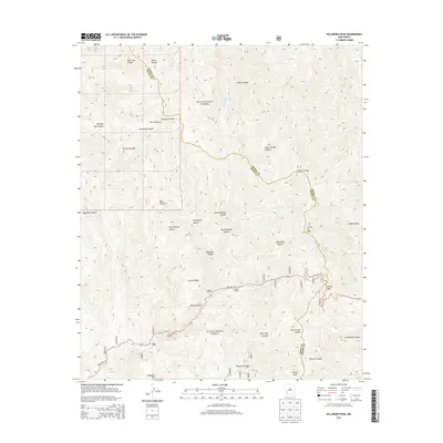
2013 Map of Hillsboro Peak
USGS Topo · Published 2013About this map
Hillsboro Peak and the high ridges of the Black Range dominate this 2013 survey of the rugged boundary between Grant and Sierra counties. Located within the Gila National Forest, the terrain is defined by a dense network of drainages and named canyons, such as Bear Trap Canyon, Noonday Canyon, and Quaking Asp Canyon. The most prominent travel corridor is State Hwy 152, which winds through the southern portion of the quadrangle, crossing the continental divide at Emory Pass. This mountain pass serves as a primary transit point through the high timber, connecting the disparate watersheds of the western range.
Find a feature on this map
37 named features on this map. Tap any name to fly to it.
Don’t see what you’re looking for? This feature index may not catch every label — zoom into the map to look around manually.
Map Details
Editions of this 2013 Hillsboro Peak Map
This is the sole edition of this map. No revisions or reprints were ever made.
Other maps of this area

1935 · Hillsboro
USGS Topo · 1:48,000

1940 · Hillsboro
USGS Topo · 1:62,500

1954 · Tularosa
USGS Topo · 1:250,000

1955 · Las Cruces
USGS Topo · 1:250,000

1956 · San Lorenzo
USGS Topo · 1:62,500

1958 · Las Cruces
USGS Topo · 1:250,000

1958 · Tularosa
USGS Topo · 1:250,000
1963 · Hay Mesa
USGS Topo · 1:24,000

1963 · Victoria Park
USGS Topo · 1:24,000

1963 · Apache Peak
USGS Topo · 1:24,000