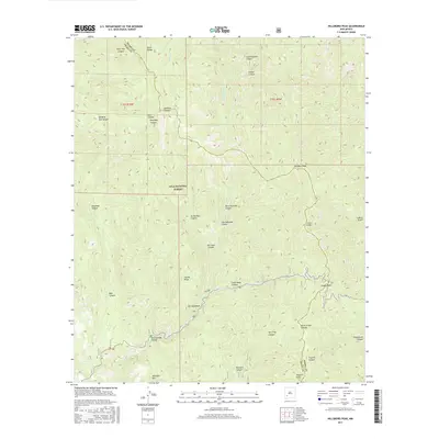
2017 Map of Hillsboro Peak
USGS Topo · Published 2017About this map
The Black Range crest forms a natural divide across this high-elevation stretch of the Gila National Forest, where the border between Grant and Sierra counties follows the rugged ridgeline. This 2017 survey details a landscape defined by deep drainages and prominent summits, including Hillsboro Peak and Sawyers Peak. High-altitude water sources like Iron Creek and Holden Prong carve through the terrain, creating complex canyon systems such as Bear Trap Canyon and Noonday Canyon. A single primary corridor, Route 152, winds through the southern portion of the map, crossing the range at Emory Pass. This crossing remains a critical point of transit through the Gila, providing access to landmarks like Thumb Ridge and the drainages of Dry Gallinas Canyon and Silver Creek Canyon.
Find a feature on this map
37 named features on this map. Tap any name to fly to it.
Don’t see what you’re looking for? This feature index may not catch every label — zoom into the map to look around manually.
Map Details
Editions of this 2017 Hillsboro Peak Map
This is the sole edition of this map. No revisions or reprints were ever made.
Other maps of this area

1935 · Hillsboro
USGS Topo · 1:48,000

1940 · Hillsboro
USGS Topo · 1:62,500

1954 · Tularosa
USGS Topo · 1:250,000

1955 · Las Cruces
USGS Topo · 1:250,000

1956 · San Lorenzo
USGS Topo · 1:62,500

1958 · Las Cruces
USGS Topo · 1:250,000

1958 · Tularosa
USGS Topo · 1:250,000
1963 · Hay Mesa
USGS Topo · 1:24,000

1963 · Victoria Park
USGS Topo · 1:24,000

1963 · Apache Peak
USGS Topo · 1:24,000