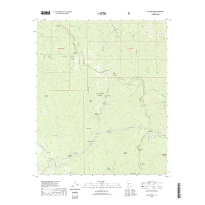
2020 Map of Hillsboro Peak
USGS Topo · Published 2020About this map
The Black Range Crest forms a dramatic geographical spine across this portion of the Gila National Forest, marking the high-altitude divide between the Rio Grande and Mimbres drainage basins. This modern topographic record details the high peaks and deeply incised canyons that define the region, such as Sawyers Peak and Haystack Mtn. The terrain is characterized by a complex network of drainages, including Animas Creek and Gallinas Creek, which cut through named landmarks like Thumb Ridge and Cross-O Mtn. Historical routes and recreational access are visible via the Scenic Trail near Emery Pass, while the Hillsboro Bypass indicates the modern infrastructure threading through this high mountain pass. Land use and naming conventions are preserved in features like Rabb Park and Deadman Canyon, offering a precise look at the wilderness geography along the Grant and Sierra County line.
Find a feature on this map
45 named features on this map. Tap any name to fly to it.
Don’t see what you’re looking for? This feature index may not catch every label — zoom into the map to look around manually.
Map Details
Editions of this 2020 Hillsboro Peak Map
This is the sole edition of this map. No revisions or reprints were ever made.
Other maps of this area

1935 · Hillsboro
USGS Topo · 1:48,000

1940 · Hillsboro
USGS Topo · 1:62,500

1954 · Tularosa
USGS Topo · 1:250,000

1955 · Las Cruces
USGS Topo · 1:250,000

1956 · San Lorenzo
USGS Topo · 1:62,500

1958 · Las Cruces
USGS Topo · 1:250,000

1958 · Tularosa
USGS Topo · 1:250,000
1963 · Hay Mesa
USGS Topo · 1:24,000

1963 · Victoria Park
USGS Topo · 1:24,000

1963 · Apache Peak
USGS Topo · 1:24,000