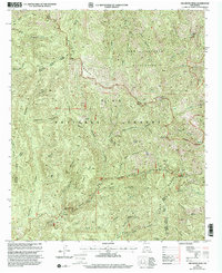
1999 Map of Hillsboro Peak
USGS Topo · Published 2002About this map
Hillsboro Peak dominates this high-altitude landscape along the Black Range, where the boundary between Sierra and Grant Counties follows the ridgelines. This area of the Gila National Forest reflects a history of high-country mining and backcountry access, with a concentration of industrial activity in the southern reaches. Mining history is preserved at the Iron Mines and Grandview Mines, while the presence of a Heliport and several ranger district labels indicates the ongoing management of the Aldo Leopold Wilderness. The complex drainage system is mapped with precision, showing the headwaters of Gallinas Canyon, Railroad Canyon, and Carbonate Creek. These deep canyons and peaks, including Cross O Mountain and Sawyers Peak, create a terrain defined by steep elevation changes near the historic Emory Pass.
Find a feature on this map
43 named features on this map. Tap any name to fly to it.
Don’t see what you’re looking for? This feature index may not catch every label — zoom into the map to look around manually.
Map Details
Editions of this 1999 Hillsboro Peak Map
This is the sole edition of this map. No revisions or reprints were ever made.
Other maps of this area

1935 · Hillsboro
USGS Topo · 1:48,000

1940 · Hillsboro
USGS Topo · 1:62,500

1954 · Tularosa
USGS Topo · 1:250,000

1955 · Las Cruces
USGS Topo · 1:250,000

1956 · San Lorenzo
USGS Topo · 1:62,500

1958 · Las Cruces
USGS Topo · 1:250,000

1958 · Tularosa
USGS Topo · 1:250,000
1963 · Hay Mesa
USGS Topo · 1:24,000

1963 · Victoria Park
USGS Topo · 1:24,000

1963 · Apache Peak
USGS Topo · 1:24,000