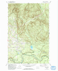
1993 Map of Hobart
USGS Topo · Published 1993About this map
Cedar River Watershed dominates this King County landscape, protecting the critical infrastructure required for urban growth. The Seattle Water Supply Intake at Landsburg serves as a focal point for the regional utility network, while the Burlington Northern Railroad skirts the southern edge of the hills. The terrain is defined by substantial peaks including Tiger Mtn, South Tiger Mtn, and Taylor Mtn, which rise above a network of drainages like Holder Creek and Webster Creek. Residential and industrial activity is concentrated near the settlement of Hobart, where grid roads like 208th Street meet the rail line. Small enclaves such as Trude and Beals are noted along the river's winding path, reflecting the late 20th-century mix of protected municipal lands, industrial transport, and rural mountain communities.
Find a feature on this map
33 named features on this map. Tap any name to fly to it.
Don’t see what you’re looking for? This feature index may not catch every label — zoom into the map to look around manually.
Map Details
Editions of this 1993 Hobart Map
This is the sole edition of this map. No revisions or reprints were ever made.
Other maps of this area

1895 · Snohomish
USGS Topo · 1:125,000

1897 · Tacoma
USGS Topo · 1:125,000

1897 · Seattle
USGS Topo · 1:125,000

1900 · Tacoma
USGS Topo · 1:125,000

1913 · Cedar Lake
USGS Topo · 1:125,000

1921 · Sultan
USGS Topo · 1:125,000

1923 · Sultan
USGS Topo · 1:125,000
1949 · Maple Valley
USGS Topo · 1:24,000
1949 · Black Diamond
USGS Topo · 1:24,000
1950 · Issaquah
USGS Topo · 1:24,000