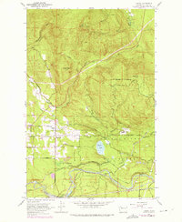
1953 Map of Hobart
USGS Topo · Published 1976About this map
The Cedar River Watershed (City of Seattle) dominates the landscape of this 1953 survey, illustrating the managed intersection of municipal infrastructure and the Washington wilderness. The Cedar River flows through the southern portion of the quadrangle, where the Seattle Water Supply Intake and Landsburg mark critical points in the city's water system. Settlement is concentrated around Hobart, featuring the Hobart Sch, while the former town of Taylor (Site) is recorded further east. Industrial activity is evidenced by a Shingle Mill and the Chicago Milwaukee St Paul and Pacific railroad line. Topographical highlights include Tiger Mtn Lookout and South Tiger Mtn, which overlook a network of timber and access routes like the Old Railroad Grade and Holder Road. A Fish Hatchery and the Walsh Lake Nursery near Walsh Lake further reflect the region's focus on natural resource management.
Find a feature on this map
39 named features on this map. Tap any name to fly to it.
Don’t see what you’re looking for? This feature index may not catch every label — zoom into the map to look around manually.
Map Details
Editions of this 1953 Hobart Map
4 editions found

Other maps of this area

1895 · Snohomish
USGS Topo · 1:125,000

1897 · Tacoma
USGS Topo · 1:125,000

1897 · Seattle
USGS Topo · 1:125,000

1900 · Tacoma
USGS Topo · 1:125,000

1913 · Cedar Lake
USGS Topo · 1:125,000

1921 · Sultan
USGS Topo · 1:125,000

1923 · Sultan
USGS Topo · 1:125,000

1949 · Maple Valley
USGS Topo · 1:24,000

1949 · Black Diamond
USGS Topo · 1:24,000

1950 · Issaquah
USGS Topo · 1:24,000