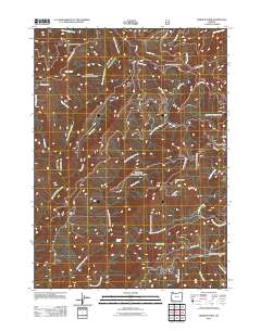
2011 Map of Hobson Horn
USGS Topo · Published 2011About this map
Bear Camp Ridge and the high point of Hobson Horn define the drainage patterns of this corner of Josephine County. This 2011 survey documents a landscape of complex watercourses where the West Fork Indigo Creek and East Fork Indigo Creek converge amidst a dense network of forest service roads. The map provides a detailed look at remote outposts such as Camp Howard and Sourgrass Camp, located near the headwaters of Sourgrass Creek.
Find a feature on this map
33 named features on this map. Tap any name to fly to it.
Don’t see what you’re looking for? This feature index may not catch every label — zoom into the map to look around manually.
Map Details
Editions of this 2011 Hobson Horn Map
This is the sole edition of this map. No revisions or reprints were ever made.
Other maps of this area

1917 · Kerby
USGS Topo · 1:125,000

1918 · Kerby
USGS Topo · 1:125,000

1945 · Kerby
USGS Topo · 1:125,000

1946 · Galice
USGS Topo · 1:62,500

1948 · Galice
USGS Topo · 1:62,500

1954 · Marial
USGS Topo · 1:62,500

1954 · Selma
USGS Topo · 1:62,500

1954 · Pearsoll Peak
USGS Topo · 1:62,500

1955 · Medford
USGS Topo · 1:250,000

1957 · Medford
USGS Topo · 1:250,000