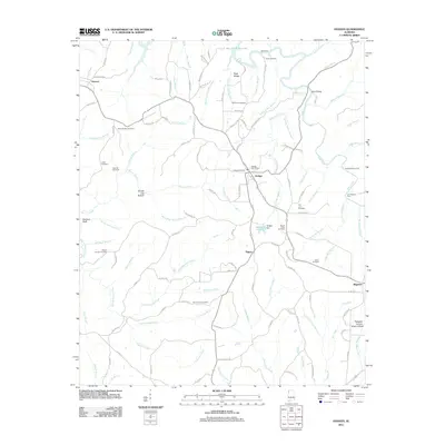
2011 Map of Hodges
USGS Topo · Published 2011About this map
Hodges serves as the central hub of this northern Alabama landscape, situated where local routes converge near the Hodges Post Office and the Hodges Cemetery. The topography is defined by the winding course of Bear Creek and its many tributaries, such as Skirum Creek and Bull Mountain Creek, which carve out distinct hollows like Rough Leg Hollow. Evidence of local industry and infrastructure appears in the Pilot Hill Gas Field to the west and the Hodges Dam near Railroad Pond.
Find a feature on this map
126 named features on this map. Tap any name to fly to it.
Don’t see what you’re looking for? This feature index may not catch every label — zoom into the map to look around manually.
Map Details
Editions of this 2011 Hodges Map
This is the sole edition of this map. No revisions or reprints were ever made.
Other maps of this area

1936 · Hodges
USGS Topo · 1:24,000

1936 · Isbell
USGS Topo · 1:24,000

1936 · South Of Hackleburg
USGS Topo · 1:24,000

1936 · Hackleburg
USGS Topo · 1:24,000

1936 · Vina
USGS Topo · 1:24,000

1936 · Halltown
USGS Topo · 1:24,000

1936 · Guinn Cross Roads
USGS Topo · 1:24,000
1945 · Isbell
USGS Topo · 1:24,000

1946 · Hackleburg
USGS Topo · 1:24,000
1946 · Guinn Cross Roads
USGS Topo · 1:24,000