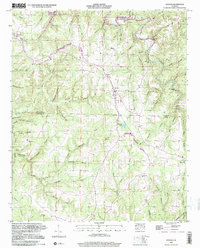
1998 Map of Hodges
USGS Topo · Published 2000About this map
Hodges and the surrounding rural landscape of Franklin and Marion counties are defined by the winding waters of Bear Creek Reservoir and its numerous tributaries. The town is situated along the Illinois Central Railroad, which cuts through the center of the sheet near the Hodges School and the local Substation. To the north, the reservoir's fingers reach into narrow valleys like Hudson Hollow, while the Tennessee Valley Divide snakes across the terrain, marking the high ground between local watersheds.
Find a feature on this map
82 named features on this map. Tap any name to fly to it.
Don’t see what you’re looking for? This feature index may not catch every label — zoom into the map to look around manually.
Map Details
Editions of this 1998 Hodges Map
This is the sole edition of this map. No revisions or reprints were ever made.
Other maps of this area

1936 · Hodges
USGS Topo · 1:24,000

1936 · Isbell
USGS Topo · 1:24,000

1936 · South Of Hackleburg
USGS Topo · 1:24,000

1936 · Hackleburg
USGS Topo · 1:24,000

1936 · Vina
USGS Topo · 1:24,000

1936 · Halltown
USGS Topo · 1:24,000

1936 · Guinn Cross Roads
USGS Topo · 1:24,000
1945 · Isbell
USGS Topo · 1:24,000

1946 · Hackleburg
USGS Topo · 1:24,000
1946 · Guinn Cross Roads
USGS Topo · 1:24,000