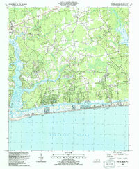
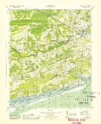
1990 Map of Holden Beach
USGS Topo · Published 1991About this map
Holden Beach stretches along the Atlantic coast, separated from the mainland by the Intracoastal Waterway and the tidal reaches of the Shallotte River. This 1990 edition captures the coastal landscape as residential development concentrated along the barrier island, while the inland Boone Neck and surrounding lowlands retained a network of traditional community anchors. Numerous country churches and family-named cemeteries, such as Lettis Grove Ch and the Riley Hewett Cem, serve as primary markers for small settlements like Sivey Town and Varnamtown. The geography is defined by the transition from agricultural land and sandpits to the maritime environment of Boone Channel and Long Bay. Evidence of older transportation methods remains visible through labels like Holden Ferry, even as boat ramps and modern beach infrastructure began to dominate the shoreline character. The map is a detailed record of Brunswick County’s coastal evolution, showing the persistent presence of inland communities like Oak Grove and Fulford alongside the growing vacation architecture of the strand.
Find a feature on this map
54 named features on this map. Tap any name to fly to it.
Don’t see what you’re looking for? This feature index may not catch every label — zoom into the map to look around manually.
Map Details
Editions of this 1990 Holden Beach Map
This is the sole edition of this map. No revisions or reprints were ever made.
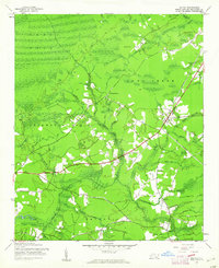
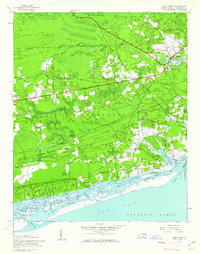
Other maps of this area
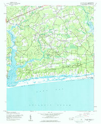
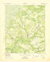
1943 · Holden Beach
USGS Topo · 1:24,000

1943 · Exum
USGS Topo · 1:24,000
1943 · Bolivia
USGS Topo · 1:24,000

1943 · Lockwoods Folly
USGS Topo · 1:24,000

1943 · Supply
USGS Topo · 1:24,000
1943 · Shallotte
USGS Topo · 1:24,000

1944 · Supply
USGS Topo · 1:31,680
1944 · Bolivia
USGS Topo · 1:31,680

1944 · Lockwoods Folly
USGS Topo · 1:31,680
1944 · Shallotte
USGS Topo · 1:31,680