
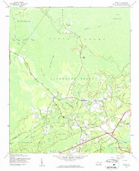
1943 Map of Supply
USGS Topo · Published 1962About this map
Green Swamp dominates this coastal Carolina landscape, revealing a complex network of wetlands and water bodies during the 1940s. The settlement of Supply sits at a crossroads near the Lockwoods Folly River, serving as a central point for the surrounding rural communities. To the west, Prospect Ridge provides a distinct change in elevation, sheltering Prospect and the Prospect Ch. Local life is further marked by the Macedonia Ch and the Royal Oak Sch, connected by winding roads and the Royal Oak Bridge.
Find a feature on this map
32 named features on this map. Tap any name to fly to it.
Don’t see what you’re looking for? This feature index may not catch every label — zoom into the map to look around manually.
Map Details
Editions of this 1943 Supply Map
2 editions found
Other maps of this area

1942 · Juniper Creek
USGS Topo · 1:24,000

1943 · Honey Island
USGS Topo · 1:24,000

1943 · Holden Beach
USGS Topo · 1:24,000

1943 · Exum
USGS Topo · 1:24,000

1943 · Bolivia
USGS Topo · 1:24,000

1943 · Lockwoods Folly
USGS Topo · 1:24,000

1943 · Lewis Swamp
USGS Topo · 1:24,000

1943 · Shallotte
USGS Topo · 1:24,000

1944 · Supply
USGS Topo · 1:31,680

1944 · Bolivia
USGS Topo · 1:31,680