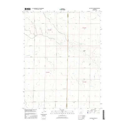
2016 Map of Holtwold Store
USGS Topo · Published 2016About this map
Holtwold Store sits at the intersection of Kendrick Rd and Corona Rd on the boundary between El Paso and Elbert counties. This high plains landscape is defined by the ephemeral drainage systems of the Arkansas River watershed, including the winding Adobe Cr and the multiple branches of Horse Cr. The region is marked by a sparse settlement pattern of isolated homesteads and ranching infrastructure, evidenced by the presence of Cutler Reservoir and Deadman Reservoir. Genealogists and local historians will find value in the specific locations of the Catholic Cem to the east and Kanza Cem to the south. These landmarks, along with a grid of rural routes like Cold Iron Rd and Big Springs Rd, provide a clear view of the modern agricultural and residential footprint in this section of the Colorado plains.
Find a feature on this map
39 named features on this map. Tap any name to fly to it.
Don’t see what you’re looking for? This feature index may not catch every label — zoom into the map to look around manually.
Map Details
Editions of this 2016 Holtwold Store Map
This is the sole edition of this map. No revisions or reprints were ever made.
Other maps of this area
1889 · Sanborn
USGS Topo · 1:125,000
1891 · Sanborn
USGS Topo · 1:125,000
1891 · Limon
USGS Topo · 1:125,000
1892 · Limon
USGS Topo · 1:125,000
1893 · Sanborn
USGS Topo · 1:125,000
1893 · Big Springs
USGS Topo · 1:125,000
1953 · Denver
USGS Topo · 1:250,000

1954 · Limon
USGS Topo · 1:250,000

1954 · Lamar
USGS Topo · 1:250,000
1954 · Pueblo
USGS Topo · 1:250,000