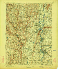
1901 Map of Holyoke
USGS Topo · Published 1924About this map
The Connecticut River forms the central artery of this late 19th-century landscape, winding past the notable Ox Bow and serving as the industrial and agricultural foundation for the Pioneer Valley. To the east, the Agricultural College at Amherst stands near a complex rail network including the Central Mass. R. R. and the Boston and Maine R. R.. The western terrain rises sharply into the eastern Berkshires, where numerous smaller peaks like Turtle Bend Mt and Mt Tekoa overlook high-elevation ponds such as Norwich Pond and Blair Pond.
Find a feature on this map
171 named features on this map. Tap any name to fly to it.
Don’t see what you’re looking for? This feature index may not catch every label — zoom into the map to look around manually.
Map Details
Editions of this 1901 Holyoke Map
4 editions found
Other maps of this area

1885 · Northampton
USGS Topo · 1:62,500

1886 · Greylock
USGS Topo · 1:62,500

1886 · Springfield
USGS Topo · 1:62,500

1886 · Hawley
USGS Topo · 1:62,500

1886 · Chesterfield
USGS Topo · 1:62,500

1886 · Northampton
USGS Topo · 1:62,500

1886 · Becket
USGS Topo · 1:62,500

1887 · Warwick
USGS Topo · 1:62,500

1887 · Palmer
USGS Topo · 1:62,500

1887 · Belchertown
USGS Topo · 1:62,500