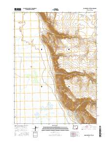
2017 Map of Home Creek Butte
USGS Topo · Published 2017About this map
Catlow Valley dominates the western half of this Harney County landscape, meeting the dramatic rise of the Catlow Rim. This sharp topographic boundary separates the low-lying basin, where ephemeral water features like West Field Lake gather, from the high desert plateau to the east. The terrain is defined by the drainage patterns of seasonal watercourses, including Dry Cr and Home Cr, which cut through the escarpment toward the valley floor. Home Creek Butte stands as a prominent landmark on the eastern heights, while further south, Threemile Canyon carves a significant path through the rim. The presence of Catlow Valley Rd provides the primary north-south transit corridor, following the base of the rim and connecting this remote rangeland. The map illustrates the classic Great Basin transition between a flat, marshy valley and the high, arid rimrock country.
Find a feature on this map
13 named features on this map. Tap any name to fly to it.
Don’t see what you’re looking for? This feature index may not catch every label — zoom into the map to look around manually.
Map Details
Editions of this 2017 Home Creek Butte Map
This is the sole edition of this map. No revisions or reprints were ever made.
Other maps of this area

1955 · Adel
USGS Topo · 1:250,000

1957 · Adel
USGS Topo · 1:250,000

1958 · Adel
USGS Topo · 1:250,000

1962 · Adel
USGS Topo · 1:250,000
1967 · Roaring Springs
USGS Topo · 1:24,000
1968 · Tombstone Canyon
USGS Topo · 1:24,000
1968 · Roaring Springs SE
USGS Topo · 1:24,000
1971 · Blitzen
USGS Topo · 1:24,000
1971 · Garrison Lake
USGS Topo · 1:24,000
1971 · Butler Hill
USGS Topo · 1:24,000