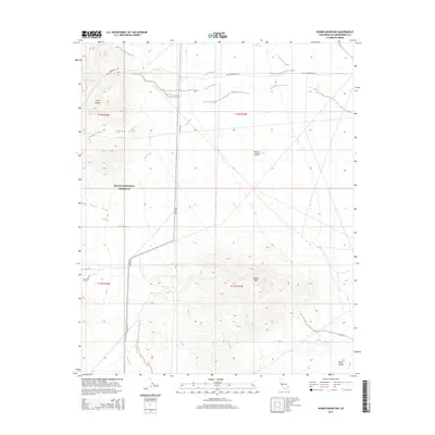
2015 Map of Homer Mountain
USGS Topo · Published 2015About this map
Old Government Rd winds across this desert landscape, tracing a path through the northern reaches of the Mojave National Preserve. This historic thoroughfare connects the rugged heights of the Piute Range in the west to the broader expanse of the Mojave Desert to the east. A critical water source in this arid environment, Piute Spring is located at the base of the range, an essential landmark for travelers navigating the corridor between the mountains and the Piute Valley. The southeastern portion of the map is dominated by the complex topography of Homer Mtn, where the elevation rises sharply from the surrounding basins. North-south transit is facilitated by Walter Rd, which skirts the western foothills of the peak. The map illustrates a classic desert geography of isolated springs and historical transit routes that defined movement across the San Bernardino County interior.
Find a feature on this map
13 named features on this map. Tap any name to fly to it.
Don’t see what you’re looking for? This feature index may not catch every label — zoom into the map to look around manually.
Map Details
Editions of this 2015 Homer Mountain Map
This is the sole edition of this map. No revisions or reprints were ever made.
Other maps of this area
1886 · Camp Mohave
USGS Topo · 1:250,000
1892 · Camp Mohave
USGS Topo · 1:250,000

1910 · Ivanpah
USGS Topo · 1:250,000

1912 · Ivanpah
USGS Topo · 1:250,000
1926 · Mohave City
USGS Topo · 1:96,000
1942 · Camp Mohave
USGS Topo · 1:250,000

1942 · Ivanpah
USGS Topo · 1:250,000

1942 · Amboy
USGS Topo · 1:250,000

1943 · Amboy
USGS Topo · 1:250,000
1943 · Fenner
USGS Topo · 1:62,500