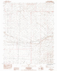
1984 Map of Homer
USGS Topo · Published 1984About this map
Homer sits at a critical junction of infrastructure in the high desert, where the heavy rails of the Atchison Topeka and Santa Fe strike a horizontal path across the arid terrain. The landscape is defined by the broad drainage of the Sacramento Wash, which flows toward the Piute Valley between the western reaches of the Sacramento Mountains and the protected lands of the East Mojave National Scenic Area.
Find a feature on this map
15 named features on this map. Tap any name to fly to it.
Don’t see what you’re looking for? This feature index may not catch every label — zoom into the map to look around manually.
Map Details
Editions of this 1984 Homer Map
This is the sole edition of this map. No revisions or reprints were ever made.
Other maps of this area

1886 · Camp Mohave
USGS Topo · 1:250,000

1892 · Camp Mohave
USGS Topo · 1:250,000

1910 · Ivanpah
USGS Topo · 1:250,000

1912 · Ivanpah
USGS Topo · 1:250,000

1926 · Mohave City
USGS Topo · 1:96,000

1942 · Camp Mohave
USGS Topo · 1:250,000

1942 · Ivanpah
USGS Topo · 1:250,000

1942 · Amboy
USGS Topo · 1:250,000

1943 · Amboy
USGS Topo · 1:250,000

1943 · Fenner
USGS Topo · 1:62,500