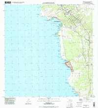
1996 Map of Honaunau
USGS Topo · Published 1998About this map
Kealakekua Bay State Historical Park and the surrounding coastline of the Big Island define this mid-1990s landscape. This survey documents a critical cultural corridor, from the Cooks Monument at Cook Point to the sacred grounds of Puuhonua O Honaunau National Historical Park. The map reveals a complex system of ancient and modern land divisions, marked by numerous Rock Walls and traditional ahupuaʻa boundaries such as Keei and Honaunau. Small coastal settlements like Keei, Hookena, and Kealia are shown alongside significant coastal features including the Napoopoo Lighthouse and the dramatic cliffs of Pali Kapu o Keoua. The presence of several Cem sites and the remote Maluhia Camp provide essential detail for genealogists and local historians tracing families along this historic shoreline.
Find a feature on this map
81 named features on this map. Tap any name to fly to it.
Don’t see what you’re looking for? This feature index may not catch every label — zoom into the map to look around manually.
Map Details
Editions of this 1996 Honaunau Map
This is the sole edition of this map. No revisions or reprints were ever made.
Other maps of this area

1928 · Kailua
USGS Topo · 1:62,500

1954 · Hawaii South
USGS Topo · 1:250,000

1954 · Hawaii North
USGS Topo · 1:250,000

1959 · Hawaii South
USGS Topo · 1:250,000

1959 · Hawaii North
USGS Topo · 1:250,000

1959 · Honaunau
USGS Topo · 1:24,000

1959 · Puu Lehua
USGS Topo · 1:24,000
1960 · Kaunene
USGS Topo · 1:24,000
1960 · Kealakekua
USGS Topo · 1:24,000

1961 · Hawaii North
USGS Topo · 1:250,000