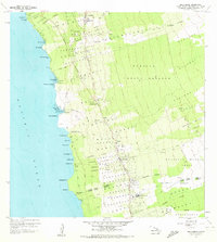
1960 Map of Kealakekua
USGS Topo · Published 1972About this map
The Burial Ground for Kuamoo Battle Warriors stands as a somber landmark on this West Hawaii coast, marking the site of a significant 1819 conflict between traditional Hawaiian forces. Moving inland from the rocky points like Puu Ohau and Kamoa Pt, the landscape transitions into the lush slopes of the Kahaluu Forest Reserve. The mid-century development of the Kona coast is anchored by the Mamalahoa Highway, where essential community hubs like Kona Hospital and the Kona Branch Univ of Hawaii Agricultural Experiment Sta are established. Education and local industry are well-represented by facilities such as Konawaena Sch and various Quarries. The map illustrates the traditional land division system with numerous named tracts like Keauhou 1 and Honalo, reflecting the long-standing ahupuaʻa structure that persists through the modern era.
Find a feature on this map
78 named features on this map. Tap any name to fly to it.
Don’t see what you’re looking for? This feature index may not catch every label — zoom into the map to look around manually.
Map Details
Editions of this 1960 Kealakekua Map
2 editions found
Other maps of this area

1928 · Kailua
USGS Topo · 1:62,500

1954 · Hawaii South
USGS Topo · 1:250,000

1954 · Hawaii North
USGS Topo · 1:250,000

1959 · Hawaii South
USGS Topo · 1:250,000

1959 · Hawaii North
USGS Topo · 1:250,000

1959 · Hualalai
USGS Topo · 1:24,000

1959 · Honaunau
USGS Topo · 1:24,000

1959 · Puu Lehua
USGS Topo · 1:24,000

1959 · Keahole Point
USGS Topo · 1:24,000

1959 · Kailua
USGS Topo · 1:24,000