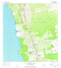
1960 Map of Kealakekua
USGS Topo · Published 1977About this map
Holualoa and the surrounding Kona coffee country are detailed during a period of transition in the mid-20th century. The settlement pattern follows the high ground along the Mamalahoa Highway, where schools like Konawaena Sch and Holualoa Sch served the local upland communities. The landscape is defined by traditional land divisions extending from the shoreline to the upper elevations, including segments like Hokukano 1 and Honuaino 2. Along the coast, the map documents a series of traditional landings and bays, from Keauhou Bay to the seasonal Disappearing Sands Beach. Inland, the Kahaluu Forest Reserve covers the higher slopes, while the historical Judd Trail cuts across the terrain. Notable local infrastructure includes the Kona Hospital and several quarries, reflecting the region's mid-century development.
Find a feature on this map
68 named features on this map. Tap any name to fly to it.
Don’t see what you’re looking for? This feature index may not catch every label — zoom into the map to look around manually.
Map Details
Editions of this 1960 Kealakekua Map
2 editions found
Other maps of this area

1928 · Kailua
USGS Topo · 1:62,500

1954 · Hawaii South
USGS Topo · 1:250,000

1954 · Hawaii North
USGS Topo · 1:250,000

1959 · Hawaii South
USGS Topo · 1:250,000

1959 · Hawaii North
USGS Topo · 1:250,000

1959 · Hualalai
USGS Topo · 1:24,000

1959 · Honaunau
USGS Topo · 1:24,000

1959 · Puu Lehua
USGS Topo · 1:24,000

1959 · Keahole Point
USGS Topo · 1:24,000

1959 · Kailua
USGS Topo · 1:24,000