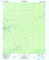
1990 Map of Honey Island
USGS Topo · Published 1991About this map
Green Swamp dominates this landscape on the border of Columbus and Brunswick counties, where vast expanses of low-lying terrain are broken by distinct topographic rises known as islands and ridges. The 1990 survey captures a region defined by its hydrology and natural savannas, including the broad Big Savanna and Crane Savanna. Human presence is concentrated around the settlement of Prosper in the northeast and small clearings such as the Bear Pen Airport near the southern edge.
Find a feature on this map
24 named features on this map. Tap any name to fly to it.
Don’t see what you’re looking for? This feature index may not catch every label — zoom into the map to look around manually.
Map Details
Editions of this 1990 Honey Island Map
This is the sole edition of this map. No revisions or reprints were ever made.
Other maps of this area

1942 · Juniper Creek
USGS Topo · 1:24,000

1943 · Honey Island
USGS Topo · 1:24,000

1943 · Exum
USGS Topo · 1:24,000

1943 · Bolivia
USGS Topo · 1:24,000

1943 · Supply
USGS Topo · 1:24,000

1943 · Lewis Swamp
USGS Topo · 1:24,000

1944 · Supply
USGS Topo · 1:31,680

1944 · Bolivia
USGS Topo · 1:31,680

1944 · Lewis Swamp
USGS Topo · 1:31,680
1950 · Supply
USGS Topo · 1:25,000