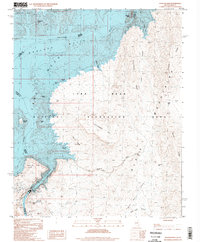
1997 Map of Hoover Dam
USGS Topo · Published 1998About this map
Lake Mead National Recreation Area dominates this landscape along the Colorado River at the border of Nevada and Arizona. The massive reservoir of Lake Mead is shown with its many named inlets and islands, including Swallow Bay, Shelter Cove, and Beehive Island. The map provides specific elevation data for the Hoover Dam and its spillway, alongside infrastructure like the Sewage Disposal Ponds and the nearby Sugarloaf Mtn. East of the river, the Black Mountains rise sharply, characterized by dramatic landforms such as Fortification Hill, Battleship Rock, and Wilson Ridge. This 1997 photoinspection records the established recreational geography of the dam site and the complex terrain of Black Canyon before modern landscape shifts.
Find a feature on this map
35 named features on this map. Tap any name to fly to it.
Don’t see what you’re looking for? This feature index may not catch every label — zoom into the map to look around manually.
Map Details
Editions of this 1997 Hoover Dam Map
This is the sole edition of this map. No revisions or reprints were ever made.
Other maps of this area

1886 · Camp Mohave
USGS Topo · 1:250,000

1886 · Saint Thomas
USGS Topo · 1:250,000

1892 · Camp Mohave
USGS Topo · 1:250,000

1893 · Saint Thomas
USGS Topo · 1:250,000

1926 · Nelson
USGS Topo · 1:96,000

1926 · Boulder Canyon
USGS Topo · 1:96,000

1942 · Camp Mohave
USGS Topo · 1:250,000

1947 · Kingman
USGS Topo · 1:250,000

1948 · Kingman
USGS Topo · 1:250,000

1952 · Henderson
USGS Topo · 1:62,500