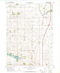
1967 Map of Hope
USGS Topo · Published 1969About this map
The Straight River winds through the eastern portion of this Steele County landscape, providing a natural corridor for the Chicago Rock Island and Pacific railroad and the burgeoning Interstate 35. This intersection of traditional rail and modern highway infrastructure centers on the community of Hope, which serves as a local hub amidst a patchwork of townships including Le Mond, Somerset, Berlin, and Summit. The map captures a well-established rural social fabric, indicated by the distribution of several one-room schoolhouses like School No 2140 and distinct burial grounds such as the Danish Cem and Berlin Cem. In the southwest, the waters of Beaver Lake and Lonergan Lake offer a break from the agricultural grid, complete with a designated Picnic Area. The landscape is heavily modified for drainage, evidenced by Judicial Ditch No 2 and Ditch No 29, reflecting the intensive land management required for local farming.
Find a feature on this map
27 named features on this map. Tap any name to fly to it.
Don’t see what you’re looking for? This feature index may not catch every label — zoom into the map to look around manually.
Map Details
Editions of this 1967 Hope Map
This is the sole edition of this map. No revisions or reprints were ever made.
Other maps of this area

1953 · Saint Paul
USGS Topo · 1:250,000

1954 · Mason City
USGS Topo · 1:250,000

1957 · Mason City
USGS Topo · 1:250,000

1958 · Mason City
USGS Topo · 1:250,000

1959 · Saint Paul
USGS Topo · 1:250,000

1962 · Owatonna
USGS Topo · 1:24,000

1962 · Saco
USGS Topo · 1:24,000

1962 · Meriden
USGS Topo · 1:24,000

1967 · Steele Center
USGS Topo · 1:24,000

1967 · Hollandale
USGS Topo · 1:24,000