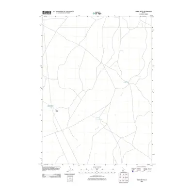
2010 Map of Horse Butte
USGS Topo · Published 2010About this map
Sailor Creek winds through this high desert plateau, feeding into several water management features that define the land's utility. The drainage system includes the prominent Sailor Creek Lake and the Felix Reservoir, which represent critical infrastructure for supporting livestock or local agriculture in this arid region of Owyhee County. The terrain is marked by the eponymous Horse Butte, a significant rise in elevation that provides a natural landmark for miles around. Human activity in this remote area is further evidenced by the Horse Butte Storage Tank, indicating the long-term efforts to manage and store water across the range. The network of secondary roads and trails shown here illustrates the remote connectivity used by ranchers and outdoorsmen navigating the space between these sparse water sources and prominent geological formations.
Find a feature on this map
5 named features on this map. Tap any name to fly to it.
Don’t see what you’re looking for? This feature index may not catch every label — zoom into the map to look around manually.
Map Details
Editions of this 2010 Horse Butte Map
This is the sole edition of this map. No revisions or reprints were ever made.
Other maps of this area

1955 · Twin Falls
USGS Topo · 1:250,000

1956 · Blue Butte
USGS Topo · 1:62,500

1958 · Twin Falls
USGS Topo · 1:250,000

1959 · Crows Nest
USGS Topo · 1:62,500

1979 · Coonskin Butte NE
USGS Topo · 1:24,000

1979 · Coonskin Butte
USGS Topo · 1:24,000

1980 · Juniper Butte
USGS Topo · 1:24,000
1980 · Crows Nest
USGS Topo · 1:24,000
1980 · Castleford Butte
USGS Topo · 1:24,000
1980 · Juniper Ranch
USGS Topo · 1:24,000