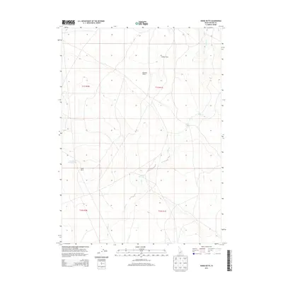
2013 Map of Horse Butte
USGS Topo · Published 2013About this map
Horse Butte dominates the local topography of this arid Owyhee County expanse, serving as a primary landmark within the northern reaches of the Bruneau Desert. This region is defined by its intermittent water systems and livestock infrastructure, where seasonal drainages like Sailor Cr navigate through the landscape. The collection of water at Felix Reservoir and Sailor Cr Lake indicates the importance of water management in this high-desert environment. Human presence is largely marked by utilitarian features such as the Horse Butte Storage Tank, which supports the ranching and resource needs of the area. The map also delineates natural depressions like Juniper Draw, illustrating the subtle variations in relief that characterize this portion of southwestern Idaho.
Find a feature on this map
11 named features on this map. Tap any name to fly to it.
Don’t see what you’re looking for? This feature index may not catch every label — zoom into the map to look around manually.
Map Details
Editions of this 2013 Horse Butte Map
This is the sole edition of this map. No revisions or reprints were ever made.
Other maps of this area

1955 · Twin Falls
USGS Topo · 1:250,000

1956 · Blue Butte
USGS Topo · 1:62,500

1958 · Twin Falls
USGS Topo · 1:250,000

1959 · Crows Nest
USGS Topo · 1:62,500

1979 · Coonskin Butte NE
USGS Topo · 1:24,000

1979 · Coonskin Butte
USGS Topo · 1:24,000

1980 · Juniper Butte
USGS Topo · 1:24,000
1980 · Crows Nest
USGS Topo · 1:24,000
1980 · Castleford Butte
USGS Topo · 1:24,000
1980 · Juniper Ranch
USGS Topo · 1:24,000