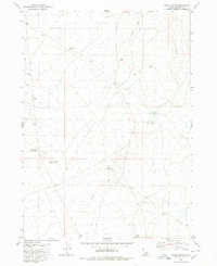
1980 Map of Horse Butte
USGS Topo · Published 1980About this map
Sailor Creek flows through this high desert terrain in Owyhee County, defining a landscape marked by essential water management for ranching and transit. Surveyed in the early 1970s, the map reveals a network of isolated infrastructure such as the Crossroads Well and several Water Tanks scattered across the sagebrush. The presence of a Corral and various Jeep Trails suggest the active use of these public lands for livestock and remote exploration. Significant landmarks like Horse Butte Long Ridge and the Horse Butte Storage Tank provide topographic orientation, while the Feliz Reservoir and Sailor Creek Lake serve as critical water sources in a region characterized by ephemeral drainages like Juniper Draw. This map documents a functional, working landscape where survival and industry are tied directly to these few named points of water and high ground.
Find a feature on this map
11 named features on this map. Tap any name to fly to it.
Don’t see what you’re looking for? This feature index may not catch every label — zoom into the map to look around manually.
Map Details
Editions of this 1980 Horse Butte Map
This is the sole edition of this map. No revisions or reprints were ever made.
Other maps of this area

1955 · Twin Falls
USGS Topo · 1:250,000

1956 · Blue Butte
USGS Topo · 1:62,500

1958 · Twin Falls
USGS Topo · 1:250,000

1959 · Crows Nest
USGS Topo · 1:62,500

1979 · Coonskin Butte NE
USGS Topo · 1:24,000

1979 · Coonskin Butte
USGS Topo · 1:24,000

1980 · Juniper Butte
USGS Topo · 1:24,000
1980 · Crows Nest
USGS Topo · 1:24,000
1980 · Castleford Butte
USGS Topo · 1:24,000
1980 · Juniper Ranch
USGS Topo · 1:24,000