
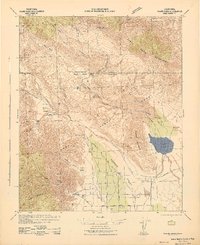
1997 Map of Hot Springs Mountain
USGS Topo · Published 2000About this map
Los Coyotes Indian Reservation occupies a significant portion of this landscape, centered on the high elevations of Coyote Mountain and Hot Springs Mountain Lookout. The settlement patterns here are largely dictated by the complex drainage systems of the San Jose Del Valle, where water sources like Agua Caliente Creek and Lost Valley Creek have historically supported small outposts and ranching operations. Traces of human activity are scattered across the terrain, from the grave near Eagles Nest to the Cem at San Ysidro.
Find a feature on this map
42 named features on this map. Tap any name to fly to it.
Don’t see what you’re looking for? This feature index may not catch every label — zoom into the map to look around manually.
Map Details
Editions of this 1997 Hot Springs Mountain Map
This is the sole edition of this map. No revisions or reprints were ever made.
Other maps of this area

1903 · Ramona
USGS Topo · 1:125,000

1904 · Indio
USGS Topo · 1:125,000

1904 · Southern California Sheet No. 2
USGS Topo · 1:250,000

1931 · Vallecito
USGS Topo · 1:125,000

1939 · Warner Springs
USGS Topo · 1:62,500

1939 · Santa Ysabel
USGS Topo · 1:62,500

1939 · Borrego
USGS Topo · 1:62,500

1941 · Clark Lake
USGS Topo · 1:62,500
1942 · Clark Lake
USGS Topo · 1:62,500
1942 · Borego
USGS Topo · 1:62,500