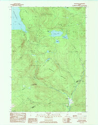
1984 Map of Houghton
USGS Topo · Published 1985About this map
Rangeley Plantation and the surrounding unorganized territories of Township D and Township E comprise this high-elevation landscape in the early 1980s. The terrain is defined by the sharp rise of Bemis Mtn and Brimstone Mountain, where numerous high-mountain water bodies like Long Pond and Sabbath Day Pond drain toward the West Branch Swift River. Local industry and transport are marked by the presence of a Gravel Pit near the eastern border and the clear path of an Old Railroad Grade winding through the valley south of Berdeen Brook.
Find a feature on this map
29 named features on this map. Tap any name to fly to it.
Don’t see what you’re looking for? This feature index may not catch every label — zoom into the map to look around manually.
Map Details
Editions of this 1984 Houghton Map
This is the sole edition of this map. No revisions or reprints were ever made.
Other maps of this area

1927 · Rumford
USGS Topo · 1:48,000

1930 · Rumford
USGS Topo · 1:62,500

1933 · Rangeley
USGS Topo · 1:48,000

1939 · Rangeley
USGS Topo · 1:62,500

1940 · Oquossoc
USGS Topo · 1:62,500

1942 · Oquossoc
USGS Topo · 1:62,500

1943 · Old Speck Mtn
USGS Topo · 1:62,500

1945 · Old Speck Mtn
USGS Topo · 1:62,500

1949 · Rangeley
USGS Topo · 1:62,500

1950 · Lewiston
USGS Topo · 1:250,000