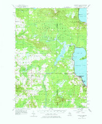
1956 Map of Houghton Lake
USGS Topo · Published 1976About this map
The vast wetlands surrounding the Muskegon River dominate this mid-century survey of the Missaukee and Roscommon county line. Settlements like Houghton Lake Heights and Star City are shown alongside the early infrastructure of the northern Michigan woods, including the Reedsburg Dam and a lone Oil Well. The map captures a landscape defined by significant water systems, from the expansive Houghton Lake and Higgins Lake to the intricate network of the Dead Stream and Cannon Creek Swamp.
Find a feature on this map
55 named features on this map. Tap any name to fly to it.
Don’t see what you’re looking for? This feature index may not catch every label — zoom into the map to look around manually.
Map Details
Editions of this 1956 Houghton Lake Map
3 editions found
Other maps of this area

1949 · Fletcher
USGS Topo · 1:62,500

1949 · Grayling
USGS Topo · 1:62,500

1950 · Cote Dame Marie
USGS Topo · 1:24,000

1950 · Fletcher
USGS Topo · 1:24,000

1951 · Pere Cheney
USGS Topo · 1:24,000

1954 · Traverse City
USGS Topo · 1:250,000

1956 · Kalkaska
USGS Topo · 1:62,500

1956 · Houghton Lake
USGS Topo · 1:62,500

1956 · Lake City
USGS Topo · 1:62,500

1957 · Harrison
USGS Topo · 1:62,500