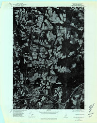
1975 Map of Houlton NE
USGS Topo · Published 1980About this map
Agricultural fields and dense woodlots define this borderland landscape in Aroostook County, recorded through mid-1970s orthophotography. The Meduxnekeag River winds through the northern half of the sheet, crossing the international boundary between Maine and New Brunswick. The settlement of Houlton occupies the southern edge, showing the intersection of major transportation routes and the dense development of the town center just before the forest and farm mosaic resumes.
Find a feature on this map
8 named features on this map. Tap any name to fly to it.
Don’t see what you’re looking for? This feature index may not catch every label — zoom into the map to look around manually.
Map Details
Editions of this 1975 Houlton NE Map
This is the sole edition of this map. No revisions or reprints were ever made.
Other maps of this area

1934 · Bridgewater
USGS Topo · 1:48,000

1938 · Bridgewater
USGS Topo · 1:62,500

1938 · Houlton
USGS Topo · 1:62,500

1951 · Houlton
USGS Topo · 1:62,500

1951 · Bridgewater
USGS Topo · 1:62,500

1953 · Bridgewater
USGS Topo · 1:50,000

1959 · Woodstock
USGS Topo · 1:250,000

1963 · Woodstock
USGS Topo · 1:250,000
1975 · Houlton SW
USGS Topo · 1:24,000
1975 · Houlton NW
USGS Topo · 1:24,000