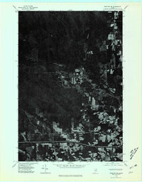
1975 Map of Houlton NW
USGS Topo · Published 1980About this map
The northern reaches of Aroostook County are captured in this mid-1970s orthophotoquad, which emphasizes the distinct land-use patterns of the Maine woods. Most notable is the drainage of Moose Brook, which winds through the central terrain amidst a complex patchwork of forest and cleared agricultural fields. Unlike a traditional topographic map, this aerial perspective reveals the sharp transitions between densely timbered sections and the rectangular clearings characteristic of the region's farming heritage. The imagery, rectified by optical scanning from 1975 photography, provides a clear view of the rural road network and isolated farmsteads that defined the Houlton NW area during this period, showing the literal footprint of human activity on the landscape.
Find a feature on this map
2 named features on this map. Tap any name to fly to it.
Don’t see what you’re looking for? This feature index may not catch every label — zoom into the map to look around manually.
Map Details
Editions of this 1975 Houlton NW Map
This is the sole edition of this map. No revisions or reprints were ever made.
Other maps of this area

1934 · Bridgewater
USGS Topo · 1:48,000

1935 · Howe Brook
USGS Topo · 1:48,000

1937 · Smyrna Mills
USGS Topo · 1:62,500

1938 · Bridgewater
USGS Topo · 1:62,500

1938 · Houlton
USGS Topo · 1:62,500

1939 · Howe Brook
USGS Topo · 1:62,500

1951 · Houlton
USGS Topo · 1:62,500

1951 · Bridgewater
USGS Topo · 1:62,500

1953 · Bridgewater
USGS Topo · 1:50,000

1954 · Howe Brook
USGS Topo · 1:62,500