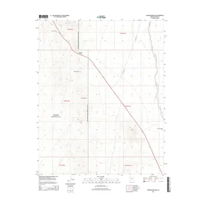
2014 Map of Housholder Pass
USGS Topo · Published 2014About this map
Housholder Pass serves as a critical transit point through the desert uplands of Mohave County, where the modern corridor of Us-93 cuts through the high terrain of the Black Mountains. This 2014 survey documents a landscape dominated by the protected federal lands of the Lake Mead National Recreation Area, which encompasses much of the western half of the quadrangle. To the east, the topography transitions into the broad alluvial expanse of the Detrital Valley. The map records the network of access roads essential for recreation and regional travel, including Temple Bar Rd and N Willow Beach Rd, which branch off the primary highway to lead toward the Colorado River's impounded waters. The area's arid character is defined by the Mojave Desert environment, characterized here by steep mountain slopes and seasonal drainage patterns typical of the American Southwest.
Find a feature on this map
15 named features on this map. Tap any name to fly to it.
Don’t see what you’re looking for? This feature index may not catch every label — zoom into the map to look around manually.
Map Details
Editions of this 2014 Housholder Pass Map
This is the sole edition of this map. No revisions or reprints were ever made.
Other maps of this area

1886 · Camp Mohave
USGS Topo · 1:250,000

1892 · Camp Mohave
USGS Topo · 1:250,000

1926 · Nelson
USGS Topo · 1:96,000

1942 · Camp Mohave
USGS Topo · 1:250,000

1947 · Kingman
USGS Topo · 1:250,000

1948 · Kingman
USGS Topo · 1:250,000

1954 · Kingman
USGS Topo · 1:250,000

1955 · Kingman
USGS Topo · 1:250,000

1958 · Kingman
USGS Topo · 1:250,000
1959 · Willow Beach
USGS Topo · 1:24,000