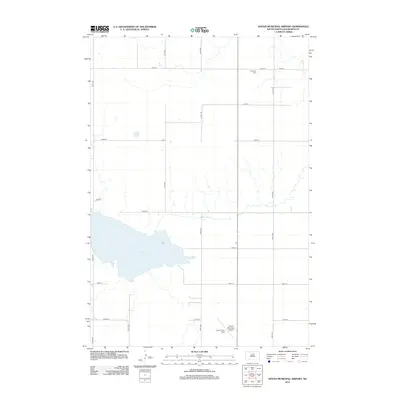
2012 Map of Hoven Municipal Airport
USGS Topo · Published 2012About this map
Theodore Cem serves as a quiet historical marker in this agricultural landscape of Walworth County, where the section-line roads of the Great Plains create a rigid grid across the terrain. The geography is dominated by Swan Lake, a prominent water body fed by the meandering Swan Lake Cr. These water features provide a natural contrast to the straight corridors of 318th Ave and 145th St. Aviation history is represented by the Harer Farm Strip, a private landing area that reflects the importance of small-scale flight in rural South Dakota. The map illustrates a region defined by its large-scale farming plots and its reliance on a systematic road network to connect remote farmsteads and rural landmarks.
Find a feature on this map
16 named features on this map. Tap any name to fly to it.
Don’t see what you’re looking for? This feature index may not catch every label — zoom into the map to look around manually.
Map Details
Editions of this 2012 Hoven Municipal Airport Map
This is the sole edition of this map. No revisions or reprints were ever made.
Other maps of this area

1954 · Aberdeen
USGS Topo · 1:250,000

1956 · Aberdeen
USGS Topo · 1:250,000

1974 · Lowry
USGS Topo · 1:24,000

1974 · Hoven
USGS Topo · 1:24,000

1974 · Hoven Muni. Airport
USGS Topo · 1:24,000

1974 · Spring Lake
USGS Topo · 1:24,000
1974 · Lowry NW
USGS Topo · 1:24,000
1974 · Flight Lake
USGS Topo · 1:24,000

1974 · Bowdle
USGS Topo · 1:24,000

1978 · Seneca NW
USGS Topo · 1:24,000