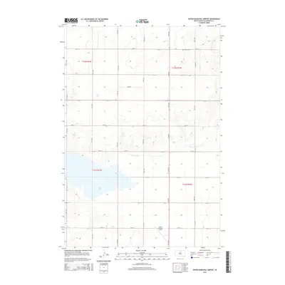
2015 Map of Hoven Municipal Airport
USGS Topo · Published 2015About this map
Swan Lake and the meandering course of Swan Lake Cr dominate this agricultural landscape in southern Walworth County. The terrain is defined by the Public Land Survey System's rigid grid, where gravel and section roads like 144th St and 319th Ave partition the prairie. This 2015 survey reveals a sparse settlement pattern typical of the Missouri Plateau, where isolated landmarks serve as vital community anchors. Theodore Cem sits quietly in the northern portion of the map, a key site for genealogists tracing local families. To the south, the Hoven Municipal Airport provides a modern utility near the town line, while family-named roads such as Kiesz Rd hint at the area's homesteading heritage and long-standing land ownership patterns.
Find a feature on this map
23 named features on this map. Tap any name to fly to it.
Don’t see what you’re looking for? This feature index may not catch every label — zoom into the map to look around manually.
Map Details
Editions of this 2015 Hoven Municipal Airport Map
This is the sole edition of this map. No revisions or reprints were ever made.
Other maps of this area

1954 · Aberdeen
USGS Topo · 1:250,000

1956 · Aberdeen
USGS Topo · 1:250,000

1974 · Lowry
USGS Topo · 1:24,000

1974 · Hoven
USGS Topo · 1:24,000

1974 · Hoven Muni. Airport
USGS Topo · 1:24,000

1974 · Spring Lake
USGS Topo · 1:24,000
1974 · Lowry NW
USGS Topo · 1:24,000
1974 · Flight Lake
USGS Topo · 1:24,000

1974 · Bowdle
USGS Topo · 1:24,000

1978 · Seneca NW
USGS Topo · 1:24,000