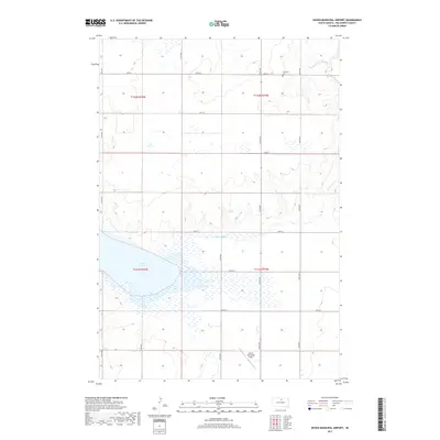
2017 Map of Hoven Municipal Airport
USGS Topo · Published 2017About this map
Swan Lake dominates the southwestern quadrant of this Walworth County landscape, serving as a significant hydrologic feature within a region defined by a regularized section-line road grid. The presence of the Theodore Cem in the northeastern section provides a specific touchpoint for genealogical research, while the Hoven Municipal Airport reflects the area's mid-century aviation infrastructure. The terrain is further shaped by the meandering path of Swan Lake Cr, which cuts through the prairie landscape, while a network of rural thoroughfares such as 319th Ave and 140th St connect the surrounding agricultural lands. The map illustrates the structured township system of the Great Plains, where land division and transportation are dictated by precise north-south and east-west alignments.
Find a feature on this map
20 named features on this map. Tap any name to fly to it.
Don’t see what you’re looking for? This feature index may not catch every label — zoom into the map to look around manually.
Map Details
Editions of this 2017 Hoven Municipal Airport Map
This is the sole edition of this map. No revisions or reprints were ever made.
Other maps of this area

1954 · Aberdeen
USGS Topo · 1:250,000

1956 · Aberdeen
USGS Topo · 1:250,000

1974 · Lowry
USGS Topo · 1:24,000

1974 · Hoven
USGS Topo · 1:24,000

1974 · Hoven Muni. Airport
USGS Topo · 1:24,000

1974 · Spring Lake
USGS Topo · 1:24,000
1974 · Lowry NW
USGS Topo · 1:24,000
1974 · Flight Lake
USGS Topo · 1:24,000

1974 · Bowdle
USGS Topo · 1:24,000

1978 · Seneca NW
USGS Topo · 1:24,000