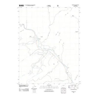
2011 Map of Howard
USGS Topo · Published 2011About this map
The Arkansas River carves a path through this part of Fremont County, anchoring the settlement of Howard and the community of Vallie along its banks. The landscape is defined by its industrial history and steep terrain, evidenced by several extractive operations such as the Pine Canyon Lode Mine and the Howard Sand Gulch Mine. These sites sit at the base of significant heights like Copper Mountain and Burned Timber Mountain, where the drainage network of Badger Creek, Howard Creek, and Cherry Creek funnels into the main river valley. Local history is preserved at the Howard Cemetery, located near the confluence of the river and several unnamed gulches. The road network, including County Rd 45 and Kerr Gulch Rd, reveals the modern rural residential development following the area's older mining and ranching footprints.
Find a feature on this map
41 named features on this map. Tap any name to fly to it.
Don’t see what you’re looking for? This feature index may not catch every label — zoom into the map to look around manually.
Map Details
Editions of this 2011 Howard Map
This is the sole edition of this map. No revisions or reprints were ever made.
Other maps of this area
1954 · Pueblo
USGS Topo · 1:250,000
1956 · Cameron Mountain
USGS Topo · 1:62,500
1957 · Pueblo
USGS Topo · 1:250,000
1958 · Pueblo
USGS Topo · 1:250,000
1959 · Black Mountain
USGS Topo · 1:62,500
1959 · Howard
USGS Topo · 1:62,500
1959 · Cotopaxi
USGS Topo · 1:62,500
1962 · Pueblo
USGS Topo · 1:250,000
1966 · Pueblo
USGS Topo · 1:250,000
1980 · Wellsville
USGS Topo · 1:24,000