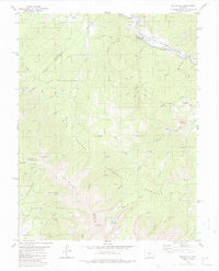
1980 Map of Wellsville
USGS Topo · Published 1980About this map
The Arkansas River carves through a canyon in the northeast corner of this Colorado landscape, where the Denver and Rio Grande Western railroad tracks follow the water's edge. This corridor contains the primary settlements of Wellsville and Swissvale, serving as a vital transportation link through the high country. The terrain is defined by extractive history and alpine recreation, evidenced by an Old RR Grade and numerous quarries and prospects scattered across the gulches.
Find a feature on this map
43 named features on this map. Tap any name to fly to it.
Don’t see what you’re looking for? This feature index may not catch every label — zoom into the map to look around manually.
Map Details
Editions of this 1980 Wellsville Map
3 editions found
Other maps of this area

1954 · Pueblo
USGS Topo · 1:250,000

1956 · Cameron Mountain
USGS Topo · 1:62,500

1956 · Poncha Springs
USGS Topo · 1:62,500

1956 · Montrose
USGS Topo · 1:250,000

1957 · Pueblo
USGS Topo · 1:250,000

1958 · Pueblo
USGS Topo · 1:250,000

1959 · Montrose
USGS Topo · 1:250,000

1959 · Bonanza
USGS Topo · 1:62,500

1959 · Howard
USGS Topo · 1:62,500

1960 · Montrose
USGS Topo · 1:250,000