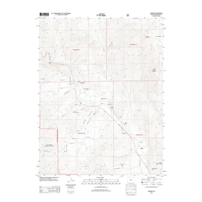
2013 Map of Howard
USGS Topo · Published 2013About this map
The Arkansas River carves a central path through this Fremont County landscape, defining the corridor for the settlement of Howard and the smaller community of Vallie. This 2013 survey illustrates the developed road network branching off Us-50 E, with neighborhood names such as Leprechaun Ln and E Blarney Stone Rd appearing alongside older landmarks like the Howard Cem. The terrain rises sharply from the river valley into the San Isabel National Forest, where the Rainbow Trail 1336 traverses the foothills.
Find a feature on this map
49 named features on this map. Tap any name to fly to it.
Don’t see what you’re looking for? This feature index may not catch every label — zoom into the map to look around manually.
Map Details
Editions of this 2013 Howard Map
This is the sole edition of this map. No revisions or reprints were ever made.
Other maps of this area

1954 · Pueblo
USGS Topo · 1:250,000

1956 · Cameron Mountain
USGS Topo · 1:62,500

1957 · Pueblo
USGS Topo · 1:250,000

1958 · Pueblo
USGS Topo · 1:250,000

1959 · Black Mountain
USGS Topo · 1:62,500

1959 · Howard
USGS Topo · 1:62,500

1959 · Cotopaxi
USGS Topo · 1:62,500

1962 · Pueblo
USGS Topo · 1:250,000

1966 · Pueblo
USGS Topo · 1:250,000
1980 · Wellsville
USGS Topo · 1:24,000