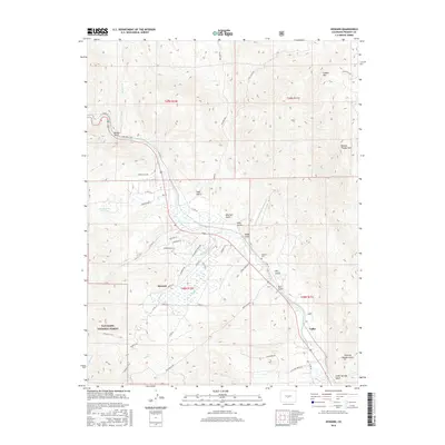
2016 Map of Howard
USGS Topo · Published 2016About this map
The Arkansas River carves a central path through this Fremont County landscape, defining the settlement patterns of Howard and Vallie. This 2016 survey illustrates the intersection of public lands and local history, with the San Isabel National Forest encroaching from the southwest and the Howard Cem marking a permanent site for local genealogy research. The terrain is marked by numerous drainages such as Badger Cr and Howard Cr, while peaks like Copper Mtn and Burned Timber Mtn loom over the valley floors. Recreation and access are detailed through mapped routes like the Rainbow Trail and Point Barr Trail, alongside a network of residential roads including Leprechaun Ln and E Blarney Stone Rd. This map documents a modern snapshot of a high-altitude river community, showing how infrastructure follows the natural corridors of the many gulches that feed into the Arkansas.
Find a feature on this map
50 named features on this map. Tap any name to fly to it.
Don’t see what you’re looking for? This feature index may not catch every label — zoom into the map to look around manually.
Map Details
Editions of this 2016 Howard Map
This is the sole edition of this map. No revisions or reprints were ever made.
Other maps of this area

1954 · Pueblo
USGS Topo · 1:250,000

1956 · Cameron Mountain
USGS Topo · 1:62,500

1957 · Pueblo
USGS Topo · 1:250,000

1958 · Pueblo
USGS Topo · 1:250,000

1959 · Black Mountain
USGS Topo · 1:62,500

1959 · Howard
USGS Topo · 1:62,500

1959 · Cotopaxi
USGS Topo · 1:62,500

1962 · Pueblo
USGS Topo · 1:250,000

1966 · Pueblo
USGS Topo · 1:250,000
1980 · Wellsville
USGS Topo · 1:24,000