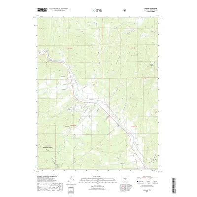
2019 Map of Howard
USGS Topo · Published 2019About this map
The Arkansas River carves a central path through this Fremont County landscape, defining the layout of rural roads and residential growth in Howard. The settlement is situated at the junction of several drainage systems, including Howard Cr and Cherry Cr, with the historic Howard Cem nearby. Higher elevations to the north and south are marked by peaks like Copper Mtn and Burned Timber Mtn, while the southwestern corner transitions into the protected lands of the San Isabel National Forest. Local infrastructure reflects a mix of traditional ranching and modern residential development, seen in the network of county roads like Co RD 45 and named lanes such as Leprechaun Ln and Shamrock Ln. Farther downstream, the settlement of Vallie sits near where Chauncy Hayden Gulch meets the river valley.
Find a feature on this map
53 named features on this map. Tap any name to fly to it.
Don’t see what you’re looking for? This feature index may not catch every label — zoom into the map to look around manually.
Map Details
Editions of this 2019 Howard Map
This is the sole edition of this map. No revisions or reprints were ever made.
Other maps of this area

1954 · Pueblo
USGS Topo · 1:250,000

1956 · Cameron Mountain
USGS Topo · 1:62,500

1957 · Pueblo
USGS Topo · 1:250,000

1958 · Pueblo
USGS Topo · 1:250,000

1959 · Black Mountain
USGS Topo · 1:62,500

1959 · Howard
USGS Topo · 1:62,500

1959 · Cotopaxi
USGS Topo · 1:62,500

1962 · Pueblo
USGS Topo · 1:250,000

1966 · Pueblo
USGS Topo · 1:250,000
1980 · Wellsville
USGS Topo · 1:24,000