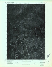
1975 Map of Howe Brook NW
USGS Topo · Published 1981About this map
Blackwater River and its tributary branches define the drainage patterns of this heavily forested Maine interior as it appeared in 1975. The landscape is a complex of wetlands and timberland, where the North Branch Blackwater River and South Branch Blackwater River converge to form the main stem. On the eastern edge of the quadrangle, the headwaters of the West Branch Presque Isle Stream originate, while Beaver Brook cuts through the southern reaches. This orthophotoquad, derived from aerial imagery, reveals the extensive network of logging roads and forest management clearings that would not be visible on a traditional line map. The contrast between dense canopy and harvested plots provides a clear look at the industrial timber operations in Aroostook County during the mid-1970s.
Find a feature on this map
6 named features on this map. Tap any name to fly to it.
Don’t see what you’re looking for? This feature index may not catch every label — zoom into the map to look around manually.
Map Details
Editions of this 1975 Howe Brook NW Map
This is the sole edition of this map. No revisions or reprints were ever made.
Other maps of this area

1931 · Ashland
USGS Topo · 1:48,000

1934 · Ashland
USGS Topo · 1:62,500

1935 · Howe Brook
USGS Topo · 1:48,000

1935 · Presque Isle
USGS Topo · 1:62,500

1939 · Howe Brook
USGS Topo · 1:62,500

1940 · Oxbow
USGS Topo · 1:62,500

1942 · Oxbow
USGS Topo · 1:62,500

1953 · Ashland
USGS Topo · 1:62,500

1953 · Presque Isle
USGS Topo · 1:62,500

1954 · Howe Brook
USGS Topo · 1:62,500