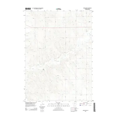
2014 Map of Howe Creek
USGS Topo · Published 2014About this map
Lindy sits in the northeast corner of this Knox County landscape, serving as a primary point of reference in an area defined by its rolling topography and agricultural drainage. The namesake Howe Cr meanders through the central and eastern sections, carving a path through the hills while several intermittent tributaries feed into it. Significant terrain features include Walker Draw, which demonstrates the erosive force of water on this prairie environment. The map details a dense grid of rural corridors such as 538th Ave and 891st Rd, reflecting the systematic sectioning of the Nebraska countryside. This 2014 representation captures the enduring rural character of the region, where family homesteads and farmsteads are linked by a network of well-defined section roads that have guided local movement for generations.
Find a feature on this map
26 named features on this map. Tap any name to fly to it.
Don’t see what you’re looking for? This feature index may not catch every label — zoom into the map to look around manually.
Map Details
Editions of this 2014 Howe Creek Map
This is the sole edition of this map. No revisions or reprints were ever made.
Other maps of this area

1955 · Sioux City
USGS Topo · 1:250,000

1958 · Sioux City
USGS Topo · 1:250,000

1959 · Sioux City
USGS Topo · 1:250,000

1974 · Sparta
USGS Topo · 1:24,000

1974 · Lindy
USGS Topo · 1:24,000
1974 · Center West
USGS Topo · 1:24,000

1974 · Bloomfield
USGS Topo · 1:24,000
1974 · Center East
USGS Topo · 1:24,000

1974 · Howe Creek
USGS Topo · 1:24,000

1974 · Bon Homme Colony
USGS Topo · 1:24,000