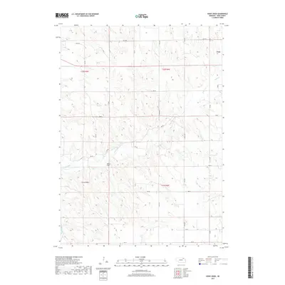
2017 Map of Howe Creek
USGS Topo · Published 2017About this map
Lindy serves as the primary focal point of this northeastern Nebraska landscape, situated near the boundary of t32n r4w. The area is defined by a dense network of drainage systems, most notably the meandering course of Howe Creek and the western reaches of Hoboe Cr. To the southwest, Bazile Creek and the distinctive geological formation known as Walker Draw demonstrate the intricate erosion patterns of the regional terrain. This 2017 U.S. Geological Survey representation documents the local section-line road grid, from 883 RD in the south to 891st RD near the northern edge, reflecting the enduring agricultural organization of Knox County. The map provides a clear look at the rural property divisions and water distribution across this section of the plains before more recent land-use changes.
Find a feature on this map
17 named features on this map. Tap any name to fly to it.
Don’t see what you’re looking for? This feature index may not catch every label — zoom into the map to look around manually.
Map Details
Editions of this 2017 Howe Creek Map
This is the sole edition of this map. No revisions or reprints were ever made.
Other maps of this area

1955 · Sioux City
USGS Topo · 1:250,000

1958 · Sioux City
USGS Topo · 1:250,000

1959 · Sioux City
USGS Topo · 1:250,000

1974 · Sparta
USGS Topo · 1:24,000

1974 · Lindy
USGS Topo · 1:24,000
1974 · Center West
USGS Topo · 1:24,000

1974 · Bloomfield
USGS Topo · 1:24,000
1974 · Center East
USGS Topo · 1:24,000

1974 · Howe Creek
USGS Topo · 1:24,000

1974 · Bon Homme Colony
USGS Topo · 1:24,000