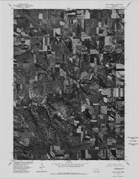
1977 Map of Howe Creek
USGS Topo · Published 1979About this map
Agricultural fields and deeply carved ravines define this portion of Knox County as it appeared in the late 1970s. Produced in cooperation with the Bureau of Indian Affairs, this orthophotoquad provides a direct visual record of the land surface, revealing the intricate drainage patterns of Howe Creek as it winds through the center of the map. Unlike a traditional topographic sheet, this imagery-based map shows the precise footprint of every farmstead, shelterbelt, and tilled field during the summer of 1977. The contrast between the flat upland plateaus and the heavily eroded slopes leading down to the creek reveals the complex geological transition of this Nebraska landscape.
Find a feature on this map
1 named feature on this map. Tap any name to fly to it.
Don’t see what you’re looking for? This feature index may not catch every label — zoom into the map to look around manually.
Map Details
Editions of this 1977 Howe Creek Map
This is the sole edition of this map. No revisions or reprints were ever made.
Other maps of this area

1955 · Sioux City
USGS Topo · 1:250,000

1958 · Sioux City
USGS Topo · 1:250,000

1959 · Sioux City
USGS Topo · 1:250,000

1974 · Sparta
USGS Topo · 1:24,000

1974 · Lindy
USGS Topo · 1:24,000
1974 · Center West
USGS Topo · 1:24,000

1974 · Bloomfield
USGS Topo · 1:24,000
1974 · Center East
USGS Topo · 1:24,000

1974 · Howe Creek
USGS Topo · 1:24,000

1974 · Bon Homme Colony
USGS Topo · 1:24,000