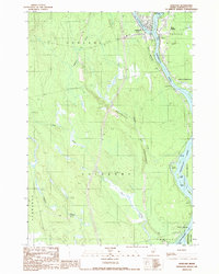
1988 Map of Howland
USGS Topo · Published 1988About this map
Howland and West Enfield anchor this 1980s landscape at the significant confluence of the Piscataquis R and the Penobscot River. The industrial and local infrastructure of the era is clearly marked by the West Enfield Dam, a Powerplant, and a Drive-In Theater situated along the eastern bank. The terrain is defined by low-lying wetlands and several named watercourses, including Meadow Brook and Pollard Brook, which thread through the wooded townships of Edinburg and Lagrange.
Find a feature on this map
28 named features on this map. Tap any name to fly to it.
Don’t see what you’re looking for? This feature index may not catch every label — zoom into the map to look around manually.
Map Details
Editions of this 1988 Howland Map
This is the sole edition of this map. No revisions or reprints were ever made.
Other maps of this area

1917 · Passadumkeag
USGS Topo · 1:62,500

1933 · Boyd Lake
USGS Topo · 1:62,500

1942 · Lincoln
USGS Topo · 1:62,500

1947 · Schoodic
USGS Topo · 1:62,500

1949 · Schoodic
USGS Topo · 1:62,500

1951 · Boyd Lake
USGS Topo · 1:50,000

1954 · Millinocket
USGS Topo · 1:250,000

1955 · Boyd Lake
USGS Topo · 1:62,500

1957 · Lincoln
USGS Topo · 1:62,500

1958 · Millinocket
USGS Topo · 1:250,000