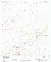
1958 Map of Huachuca City
USGS Topo · Published 1991About this map
Huachuca City stands as a primary focal point at the edge of the Fort Huachuca Military Reservation during the mid-century expansion of Cochise County. The landscape is defined by the valley of the Babocomari River and the sweeping terrain of San Ignacio Del Babocomari, where cattle ranching and military presence intersect. While the northern reaches are marked by stock-raising landmarks like Boedecker Tank and Homestead Tank, the southern portion reflects the town's growth with a dedicated Trailer Park and a small Cem. Evidence of mid-century infrastructure is visible in the network of pipelines and the Landing Strip near the river. This survey captures a specific era when small settlements like Campstone and family holdings such as Hunt Ranch remained distinct features of the high desert basin.
Find a feature on this map
27 named features on this map. Tap any name to fly to it.
Don’t see what you’re looking for? This feature index may not catch every label — zoom into the map to look around manually.
Map Details
Editions of this 1958 Huachuca City Map
4 editions found
Other maps of this area

1915 · Benson
USGS Topo · 1:125,000

1922 · St. David
USGS Topo · 1:62,500

1926 · Whetstone
USGS Topo · 1:62,500

1932 · Fairbank
USGS Topo · 1:62,500

1938 · Huachuca
USGS Topo · 1:62,500

1943 · Benson
USGS Topo · 1:125,000

1948 · Fort Huachuca NE
USGS Topo · 1:24,000
1948 · Mustang Mountains
USGS Topo · 1:24,000
1948 · Fort Huachuca SW
USGS Topo · 1:24,000
1948 · Fort Huachuca
USGS Topo · 1:24,000