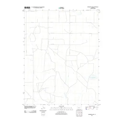
2010 Map of Hubbard Lake
USGS Topo · Published 2010About this map
Adobe Creek and its tributary, the East Fork Adobe Creek, dominate the drainage of this Lincoln County landscape, carving shallow paths through the high plains. The area is defined by a rigid section-line road network, including thoroughfares such as County Road T and County Road R, which segment the terrain for agricultural use. While the region is largely defined by open range and dryland farming, water management is evident through features like Redwood Tank and the eponymous Hubbard Lake. This 2010 survey reflects the enduring rural character of eastern Colorado, where transportation is bound to the cardinal directions and the survival of local livestock and crops depends on the intermittent flow of creek beds and established reservoirs.
Find a feature on this map
13 named features on this map. Tap any name to fly to it.
Don’t see what you’re looking for? This feature index may not catch every label — zoom into the map to look around manually.
Map Details
Editions of this 2010 Hubbard Lake Map
This is the sole edition of this map. No revisions or reprints were ever made.
Other maps of this area

1889 · Sanborn
USGS Topo · 1:125,000

1891 · Sanborn
USGS Topo · 1:125,000

1891 · Arroyo
USGS Topo · 1:125,000

1893 · Arroyo
USGS Topo · 1:125,000

1893 · Sanborn
USGS Topo · 1:125,000

1954 · Lamar
USGS Topo · 1:250,000

1958 · Lamar
USGS Topo · 1:250,000

1975 · Stanley Gulch
USGS Topo · 1:24,000

1978 · Barrel Springs Draw
USGS Topo · 1:24,000
1978 · Metz Springs
USGS Topo · 1:24,000