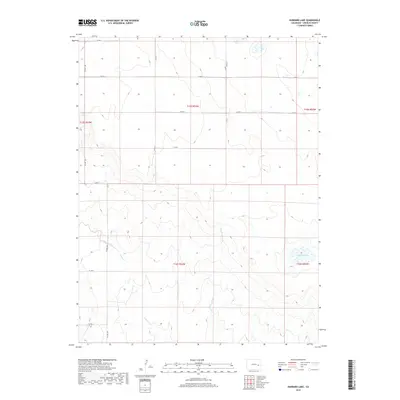
2019 Map of Hubbard Lake
USGS Topo · Published 2019About this map
Adobe Creek and its tributary, the E Fork Adobe Cr, define the drainage patterns across this section of the high plains in Lincoln County. The landscape is marked by a rigid rectangular grid of section lines and county roads, including Co RD S and Co RD R, which facilitate movement through this ranching and agricultural region. Hubbard Lake serves as a primary water feature in the southeastern portion of the survey, while Redwood Tank provides a localized water source in the western sections. The presence of Co Hwy 109 running north-south through the western edge suggests its role as a primary artery for local travel. This 2019 survey documents the enduring spatial organization of the Public Land Survey System, showing the townships and ranges that have governed land ownership and management in Colorado for generations.
Find a feature on this map
19 named features on this map. Tap any name to fly to it.
Don’t see what you’re looking for? This feature index may not catch every label — zoom into the map to look around manually.
Map Details
Editions of this 2019 Hubbard Lake Map
This is the sole edition of this map. No revisions or reprints were ever made.
Other maps of this area

1889 · Sanborn
USGS Topo · 1:125,000

1891 · Sanborn
USGS Topo · 1:125,000

1891 · Arroyo
USGS Topo · 1:125,000

1893 · Arroyo
USGS Topo · 1:125,000

1893 · Sanborn
USGS Topo · 1:125,000

1954 · Lamar
USGS Topo · 1:250,000

1958 · Lamar
USGS Topo · 1:250,000

1975 · Stanley Gulch
USGS Topo · 1:24,000

1978 · Barrel Springs Draw
USGS Topo · 1:24,000
1978 · Metz Springs
USGS Topo · 1:24,000