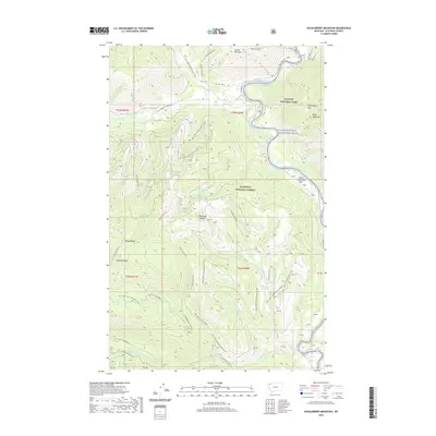
2020 Map of Huckleberry Mountain
USGS Topo · Published 2020About this map
Glacier National Park and the Flathead National Forest meet along the dramatic corridor of the Flathead Wild and Scenic River in this 2020 topographic study. The landscape is defined by the high elevations of the Whitefish Range and the Smoky Range, with notable summits including Glacier View Mtn, Standard Peak, and Huckleberry Mtn. The drainage network is dense, featuring Big Creek, Langford Creek, and the seasonal Kimmerly Sm (Snow) flows. Human access is primarily through a network of National Forest Development Roads and the Camas Road, which provides entry into the park near the Apgar Mountains. This modern survey details the transition from the low-lying Great Northern Flats to the high ridges of Demers Ridge, mapping the complex terrain of the northern Rockies.
Find a feature on this map
48 named features on this map. Tap any name to fly to it.
Don’t see what you’re looking for? This feature index may not catch every label — zoom into the map to look around manually.
Map Details
Editions of this 2020 Huckleberry Mountain Map
This is the sole edition of this map. No revisions or reprints were ever made.
Other maps of this area

1906 · Kintla Lakes
USGS Topo · 1:125,000

1938 · Kintla Lakes
USGS Topo · 1:125,000

1943 · Kalispell
USGS Topo · 1:125,000

1957 · Kalispell
USGS Topo · 1:250,000

1960 · Kalispell
USGS Topo · 1:250,000

1961 · Kalispell
USGS Topo · 1:250,000

1962 · Hungry Horse
USGS Topo · 1:24,000
1962 · Whitefish
USGS Topo · 1:24,000
1962 · Columbia Falls North
USGS Topo · 1:24,000
1966 · Camas Ridge West
USGS Topo · 1:24,000