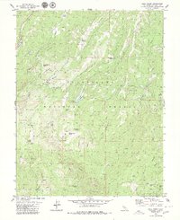
1979 Map of Hull Creek
USGS Topo · Published 1979About this map
Stanislaus National Forest defines the character of this mountain landscape, where historical timber and grazing activity is evidenced by numerous camps and named meadows. The Clavey River and Hull Creek carve through the terrain, flanked by notable landmarks such as Dodge Ridge and Sugarpine. This 1970s survey documents a network of family-named features and seasonal sites, including Fahey Cabin, Sam Williams Spring, and the Fahey Meadow area. The presence of an Old Railroad Grade winding through the canyons near Camp Twentyfour (Site) and Camp Twentyone points to the region's industrial heritage in logging and resource extraction. Smaller settlements and outpost sites like Camp Ida and Camp Niagara (Site) are scattered among the ridges, connected by a network of jeep trails and creek drainages such as Lily Creek and Trout Creek.
Find a feature on this map
49 named features on this map. Tap any name to fly to it.
Don’t see what you’re looking for? This feature index may not catch every label — zoom into the map to look around manually.
Map Details
Editions of this 1979 Hull Creek Map
This is the sole edition of this map. No revisions or reprints were ever made.
Other maps of this area

1891 · Big Trees
USGS Topo · 1:125,000

1893 · Sonora
USGS Topo · 1:125,000

1894 · Big Trees
USGS Topo · 1:125,000

1896 · Dardanelles
USGS Topo · 1:125,000

1896 · Sonora
USGS Topo · 1:125,000

1897 · Sonora
USGS Topo · 1:125,000

1897 · Big Trees
USGS Topo · 1:125,000

1897 · Yosemite
USGS Topo · 1:125,000

1898 · Dardanelles
USGS Topo · 1:125,000

1898 · Sonora
USGS Topo · 1:125,000