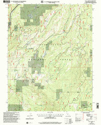
2001 Map of Hull Creek
USGS Topo · Published 2004About this map
The high Sierra Nevada landscape of the Stanislaus National Forest is defined here by its steep drainages and a legacy of mountain camps. Dodge Ridge dominates the western portion of the map, rising above the North Fork Tuolumne River. This area has long served as a hub for forest management and seasonal residence, as evidenced by several marked locations like Fahey Cabin and the former locations of Camp Twentyfour and Camp Niagara.
Find a feature on this map
54 named features on this map. Tap any name to fly to it.
Don’t see what you’re looking for? This feature index may not catch every label — zoom into the map to look around manually.
Map Details
Editions of this 2001 Hull Creek Map
This is the sole edition of this map. No revisions or reprints were ever made.
Other maps of this area

1891 · Big Trees
USGS Topo · 1:125,000

1893 · Sonora
USGS Topo · 1:125,000

1894 · Big Trees
USGS Topo · 1:125,000

1896 · Dardanelles
USGS Topo · 1:125,000

1896 · Sonora
USGS Topo · 1:125,000

1897 · Sonora
USGS Topo · 1:125,000

1897 · Big Trees
USGS Topo · 1:125,000

1897 · Yosemite
USGS Topo · 1:125,000

1898 · Dardanelles
USGS Topo · 1:125,000

1898 · Sonora
USGS Topo · 1:125,000